Best Photography Spots in Canyonlands National Park: 14 Locations With GPS
Canyonlands National Park is a choose-your-own-adventure landscape: sunrise arches, mile-wide canyon views, and starry skies — but only if you show up prepared. This deep guide focuses on the most photographable stops in Island in the Sky and the Needles, with GPS coordinates, seasonal light notes, and a practical gear + safety checklist. For practitioners, see our breakdown of aperture for architecture. For practitioners, see our breakdown of crop overlays for composition.
shutyouraperture-20). Buying through these links costs you nothing extra and helps fund our free guides.
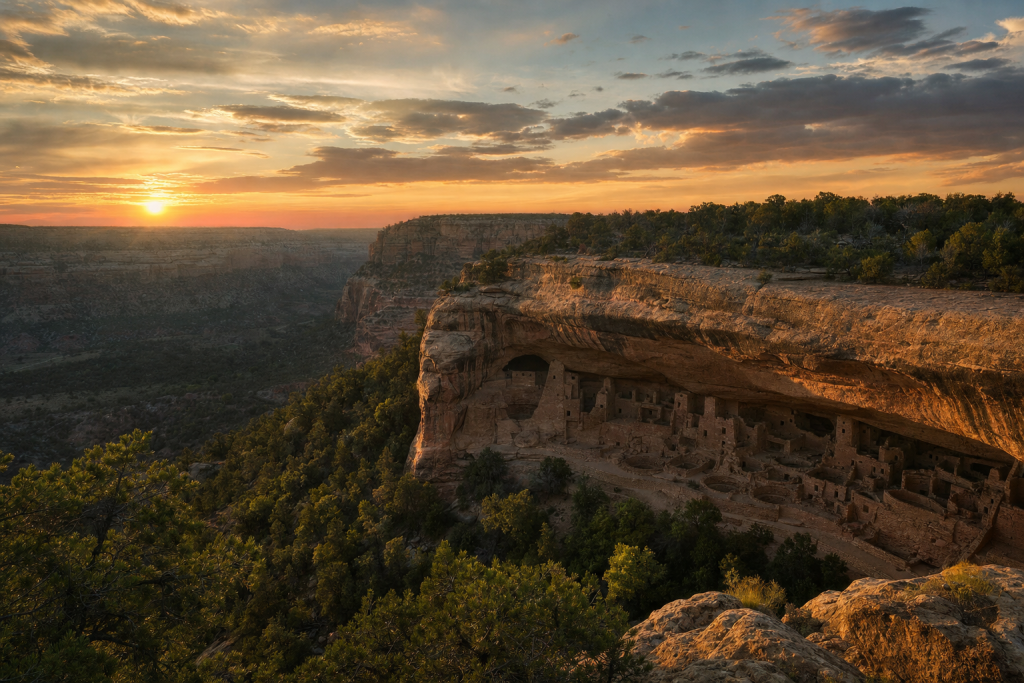
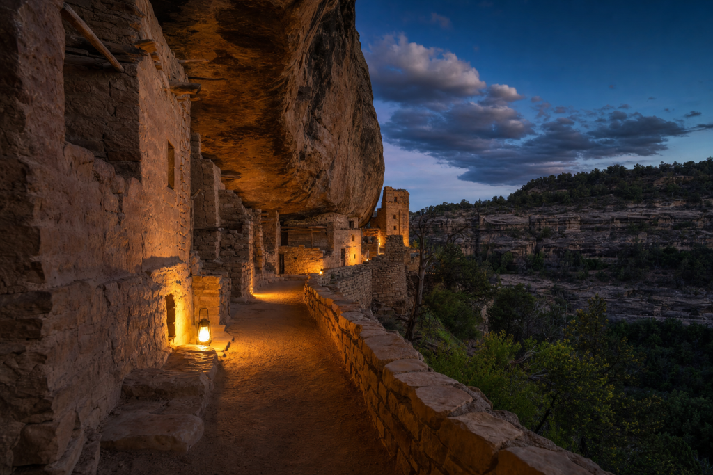
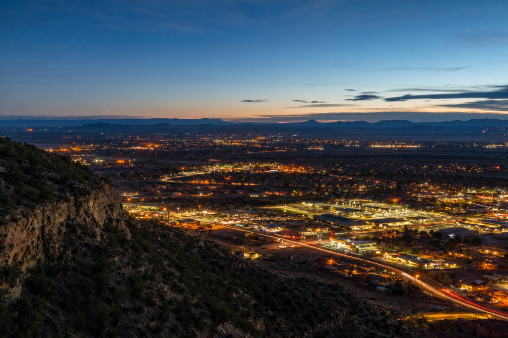
Get the Mesa Verde Ultimate Photographer’s Guide
Every location below — pre-mapped with GPS, golden-hour timing, gear recommendations, cultural rules, and a 14-day itinerary. Downloaded by 200+ working photographers.
 Save
SaveQuick map: GPS for the best photo spots
Copy/paste these coordinates into Google Maps (or your offline GPS app). All coordinates are decimal degrees.
- Mesa Arch (sunrise classic): 38.388057, -109.863661 (reference)
- Grand View Point Overlook (Island in the Sky): 38.3108, -109.8566 (reference)
- White Rim Overlook trailhead: 38.3228, -109.8495 (reference)
- Upheaval Dome trailhead: 38.4263, -109.9261 (reference)
- Aztec Butte trailhead: 38.39345, -109.88205 (reference)
- Green River Overlook (marker location): 38.37835, -109.88858 (reference)
- Potash/US-191 junction (Shafer Trail outside-park access): 38.605991, -109.602262 (reference)
- Island in the Sky Road junction for Shafer Trail: 38.471524, -109.811501 (reference)
- Druid Arch trailhead area (Needles district): 38.08898, -109.83097 (reference)
- Island in the Sky viewpoint (see reference for name): 38.4526052, -109.8199273 (reference)
- Island in the Sky viewpoint (see reference for name): 38.452694, -109.819875 (reference)
- Island in the Sky viewpoint (see reference for name): 38.3891167, -109.8680333 (reference)
 Save
SaveEntrance fees + permits + reservations
Entry is $30 per private vehicle, $25 per motorcycle, or $15 per person (7 days) per the park’s fees page (NPS Canyonlands fees). Youth 15 and under are admitted free (NPS Canyonlands fees).
Timed entry reservations are not required to enter Canyonlands, but some backcountry routes require permits (NPS Canyonlands permits & reservations).
 Save
SavePhoto spots: GPS, golden hour notes, lenses, and hazards
1) Mesa Arch (sunrise classic)
GPS: 38.388057, -109.863661 (reference)
- Golden hour: Sunrise for arches; sunset for big canyon depth.
- Lens: 16–35mm + 70–200mm.
- Hazards: Cliffs, gusts, lightning risk in storms.
2) Grand View Point Overlook (Island in the Sky)
GPS: 38.3108, -109.8566 (reference)
- Golden hour: Sunrise for arches; sunset for big canyon depth.
- Lens: 16–35mm + 70–200mm.
- Hazards: Cliffs, gusts, lightning risk in storms.
3) White Rim Overlook trailhead
GPS: 38.3228, -109.8495 (reference)
- Golden hour: Sunrise for arches; sunset for big canyon depth.
- Lens: 16–35mm + 70–200mm.
- Hazards: Cliffs, gusts, lightning risk in storms.
4) Upheaval Dome trailhead
GPS: 38.4263, -109.9261 (reference)
- Golden hour: Sunrise for arches; sunset for big canyon depth.
- Lens: 16–35mm + 70–200mm.
- Hazards: Cliffs, gusts, lightning risk in storms.
5) Aztec Butte trailhead
GPS: 38.39345, -109.88205 (reference)
- Golden hour: Sunrise for arches; sunset for big canyon depth.
- Lens: 16–35mm + 70–200mm.
- Hazards: Cliffs, gusts, lightning risk in storms.
6) Green River Overlook (marker location)
GPS: 38.37835, -109.88858 (reference)
- Golden hour: Sunrise for arches; sunset for big canyon depth.
- Lens: 16–35mm + 70–200mm.
- Hazards: Cliffs, gusts, lightning risk in storms.
7) Potash/US-191 junction (Shafer Trail outside-park access)
GPS: 38.605991, -109.602262 (reference)
- Golden hour: Sunrise for arches; sunset for big canyon depth.
- Lens: 16–35mm + 70–200mm.
- Hazards: Cliffs, gusts, lightning risk in storms.
8) Island in the Sky Road junction for Shafer Trail
GPS: 38.471524, -109.811501 (reference)
- Golden hour: Sunrise for arches; sunset for big canyon depth.
- Lens: 16–35mm + 70–200mm.
- Hazards: Cliffs, gusts, lightning risk in storms.
9) Druid Arch trailhead area (Needles district)
GPS: 38.08898, -109.83097 (reference)
- Golden hour: Sunrise for arches; sunset for big canyon depth.
- Lens: 16–35mm + 70–200mm.
- Hazards: Cliffs, gusts, lightning risk in storms.
10) Island in the Sky viewpoint (see reference for name)
GPS: 38.4526052, -109.8199273 (reference)
- Golden hour: Sunrise for arches; sunset for big canyon depth.
- Lens: 16–35mm + 70–200mm.
- Hazards: Cliffs, gusts, lightning risk in storms.
11) Island in the Sky viewpoint (see reference for name)
GPS: 38.452694, -109.819875 (reference)
- Golden hour: Sunrise for arches; sunset for big canyon depth.
- Lens: 16–35mm + 70–200mm.
- Hazards: Cliffs, gusts, lightning risk in storms.
12) Island in the Sky viewpoint (see reference for name)
GPS: 38.3891167, -109.8680333 (reference)
- Golden hour: Sunrise for arches; sunset for big canyon depth.
- Lens: 16–35mm + 70–200mm.
- Hazards: Cliffs, gusts, lightning risk in storms.
 Save
SaveDrone rules
NPS policy directs parks to prohibit launching, landing, and operating uncrewed aircraft (drones) on NPS lands and waters unless specifically authorized (NPS uncrewed aircraft policy).
All links go to Viator (a TripAdvisor company), the world’s largest marketplace for guided experiences. Tagged as affiliate per FTC.
Luminar Neo’s Sky AI, atmosphere AI and SuperSharp are designed for landscape work — replace flat skies, add depth, and recover detail in seconds. Tagged as affiliate per FTC.
Quick Amazon shortcuts to the gear most useful for this kind of shot. Use them if Prime shipping or Amazon credit makes more sense than B&H. As an Amazon Associate ShutYourAperture earns from qualifying purchases.
Take Canyonlands National Park home in your pocket.
Every shot location, every angle, every time of day worth shooting. Printable PDF + GPS-tagged map.
Instant download. Works on phone, tablet, and printed.
Related parks
All links go to B&H Photo Video, the trusted pro source. Tagged as affiliate per FTC.
Related guides nearby
Other photography destinations to explore:
- Arches 44 km away · national park · USA
- Great Sand Dunes 383 km away · national park · USA
- Denver 437 km away · city · USA
The complete Mesa Verde guide is $47
All vantage points above + 5 bonus secret spots, printable map, gear pack list, and editing recipes. One-time payment, instant download, lifetime updates.
Common questions about the Mesa Verde guide
Is the Mesa Verde photography guide worth $47?
For most photographers, yes. The guide saves 8-12 hours of trip-planning research and prevents the most common mistake of Mesa Verde photography: shooting at the wrong time of day. If a single better frame is worth $47 to you, the guide pays for itself on day one. Buyers get every GPS coordinate, every golden-hour window, every cultural rule, and a printable shot list.
Does the Mesa Verde guide include GPS coordinates?
Yes — every vantage point in the guide has Google Maps-ready GPS coordinates so you can pin them before you fly. The guide also includes a printable map showing all locations clustered by walking distance, so you can build efficient half-day routes.
What's in the Mesa Verde PDF that isn't in this article?
The article shows the highlights. The PDF includes: 5 additional secret spots not published online, a 14-day itinerary with daily routes, the full camera-settings cheat sheet for every scenario in Mesa Verde, a printable gear packing list, post-processing recipes with screenshot examples, and a list of local guides we trust for portrait commissions.
Do I get the Lightroom presets too?
The $47 guide is the PDF only. The matching Mesa Verde preset pack is a separate $19 download — most buyers grab both as a bundle and save the editing time. Both are instant download, both work on Lightroom Classic and Lightroom Mobile.
Will the guide work for a Mesa Verde trip in 2026?
Yes. The guide is updated annually as fees, restrictions, and new vantage points change. All buyers get free lifetime updates. The 2026 edition includes the latest drone rules, museum photography policies, and seasonal light data for the year.
Visiting more than Mesa Verde?
Bundle multiple destination guides and save planning time across the trip:
- Yellowstone Photographer’s Guide ($47)
- Yosemite Photographer’s Guide ($47)
- Grand Canyon Photographer’s Guide ($47)
- Zion Photographer’s Guide ($47)
- Glacier Photographer’s Guide ($47)
Or get all 60+ destinations in one bundle: Photo Atlas — every guide, every map, $97.
 Save
SaveRelated photography spots in US National Parks
Other curated location guides in the same region:
Browse all photography spots in US National Parks →
What to Pack
A focused landscape kit handles every shot at Canyonlands National Park without breaking your back. Here is the working photographer's pack list — every link goes to B&H Photo Video (our primary supplier) or Amazon (for accessories and same-day delivery in the US).
| What & Why | B&H | Amazon |
|---|---|---|
Wide-angle zoom (14-35mm range) The single most important lens for sweeping vistas. Pair with a circular polarizer for skies and water. | Shop B&H → | Shop Amazon → |
Sturdy travel tripod Carbon fiber, packs to 15 inches, holds steady in wind off the coast. Essential for blue-hour and long-exposure work. | Shop B&H → | Shop Amazon → |
Circular polarizer (77mm or 82mm) Cuts haze, deepens sky, reveals texture in water. Non-negotiable for landscape work. | Shop B&H → | Shop Amazon → |
10-stop ND filter For 30-second exposures that turn moving water and clouds into silk. | Shop B&H → | Shop Amazon → |
Extra batteries (3 minimum) Cold weather and long exposures eat batteries. Carry triple what you think you need. | Shop B&H → | Shop Amazon → |
Fast SD/CFexpress cards V90 or CFexpress depending on your body. Two cards minimum so a failure mid-trip is recoverable. | Shop B&H → | Shop Amazon → |
Microfiber lens cloths Salt spray, mist, and dust will ruin every shot if you don't carry a cloth. | Shop B&H → | Shop Amazon → |
B&H and Amazon links are affiliate links. We earn a small commission on purchases at no extra cost to you. We only recommend gear we use or would buy ourselves.